
Digital Twins and Heritage Mapping
If you’ve ever thought that communicating through two dimensional (2D) maps could be done more effectively, you’re right!
We want to talk to you about Digital Twins; an asset management tool that displays built environments in a three-dimensional (3D) Geographic Information System (GIS). Typically, digital twins display built environments and assets in a ‘city’ context (think buildings, roads, bridges), so we often associate digital twin technology to metropolitan or industrial use cases. However, as applications of GIS become more accessible, the role of digital twins is evolving.
Put simply, this technology is not only cutting edge, it can also accommodate for Indigenous organisations’ and Elders’ preference of communicating knowledge in a 3D environment. For a deeper understanding on why Indigenous Elders are better equipped to communicate knowledge of Country in a 3D setting, read our previous blog, ‘Mapping Country in 3D just makes sense. Here’s why.’
Winyama is using digital twin software, such as Skyline TerraExplorer, in collaboration with Indigenous communities to visualise the natural environment and the heritage that is associated with those places.
Alongside Skyline, Winyama has innovated the way we understand the typical use case of a digital twin. The 3D technology responds to Elder’s and knowledge holders’ intimate relationship with the landscape, and the technical capabilities work as a communication tool between Indigenous groups and their non-Indigenous collaborators.
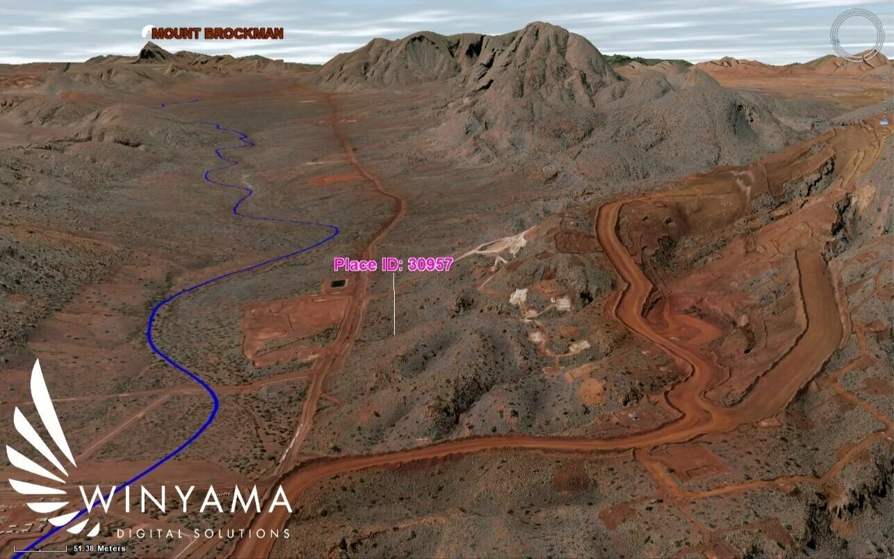
TerraExplorer's high resolution and hyper realistic replica of Country with an identified cultural site.
How is digital twin software useful for Indigenous communities?
We are glad you asked - the technical capabilities of a digital twin unlock so much potential for mapping use cases already seen within Indigenous groups:
Prescribed Body Corporates (PBCs)
3D GIS technology is beneficial for PBCs for two main reasons:
It is an excellent communication tool
It assists with threat analysis
PBCs regularly act as an intermediary between their members and stakeholders. Digital twin’s high resolution and hyper realistic replica of Country ensures Indigenous people are better equipped to collaborate with these stakeholders about decisions that impact their community and Country.
TerraExplorer helps to represent the effects of exploration or disturbances on Country, and also makes it easier for Indigenous Elder’s to orientate themselves in the landscape, to accurately and confidently identify sites of cultural significance.
3D GIS software also provides comprehensive tools for communicating and responding to industrial pressures, where Boards and decision makers may require tangible information in the form of technical reports or interactive maps.
Indigenous Ranger Groups
Indigenous Ranger Groups also greatly benefit from incorporating 3D GIS software into their work.
Field and drone data captured by Indigenous Ranger Groups can be visualised in 3D GIS software such as TerraExplorer to inform future work. This may include comparing the landscape over time to analyse past performances, analysing the environment to prioritise upcoming tasks, and studying the terrain to plan for upcoming field trips.
As well as conducting work on the ground, Indigenous Ranger Groups are also required to report back to stakeholders and grant agencies, and 3D GIS technology has the ability to help with this process.
So, how is TerraExplorer’s Skyline different from Google Earth Pro?
TerraExplorer might sound familiar to other 3D visualisation technologies, but there are a number of key differences that are important to distinguish. We've broken down the main ones for you here:
The immersion experience
3D GIS applications such as TerraExplorer, use virtual reality (VR) technology to propel the capabilities of 3D visualisation tools such as Google Earth Pro. VR technology allows map makers and map viewers to immerse themselves in the mapped environment and feel as though they are standing on Country.
As Elder’s and knowledge holders are able to connect with Country, and reconnect with areas that have become inaccessible in this 3D environment, knowledge exchange with stakeholders becomes more rich, relevant and collaborative.

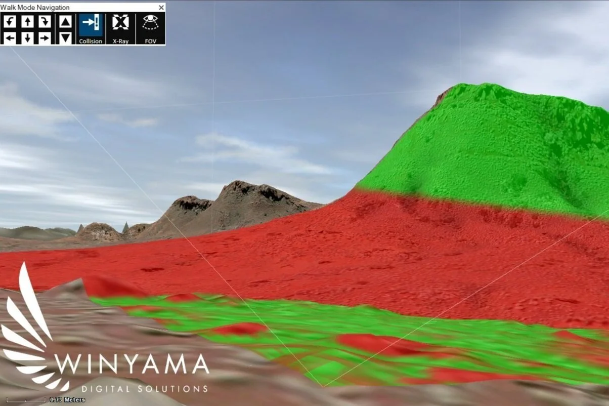
These image shows what can and cannot be seen from a person's point of view - identified where the trianglemeets in the landscape. The green shows what can be seen from the naked eye and red shows what cannot. The person's view point can also be adjusted to a specific height for maximum accuracy.
Technical capabilities
In addition to VR technology,TerraExplorer boasts a much higher resolution of imagery and has the ability to take accurate measurements in 3D. It also allows you to compare changes to terrain and imagery over time, and calculate the changes in the terrain’s volume as a result of digging ditches or creating hills or rises. Similarly, you can conduct a slope or flood analysis on the different terrain measurements over time.
One of the most useful tools in the TerraExplorer suite is its ability to view external GIS datasets. This data integration allows users to visualise data held by other organisations, and can accommodate Web Feature Service (WFS) and Web Map Service (WMS) data. This is a capability of a great 3D GIS and far exceeds the capabilities of 3D visualisation tools such as Google Earth Pro.
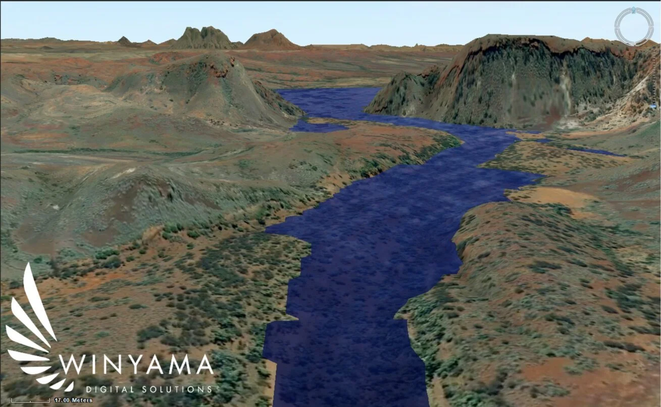
If you have data on how much water levels are predicted to rise in future or following an industrial change, this can be accurately mapped within TerraExplorer to show you how high the new water level will be and exactly how it will sit in the landscape as seen above
Licensing
With all of these extra capabilities, you might be wondering why the comparison at all, and that comes down to cost. While Google Earth Pro is free for all users, TerraExplorer is a licensed commercial product.
Through our partner NGIS, Winyama has access to TerraExplorer’s full capabilities, and we’d love to chat with you about how we can incorporate this technology into your next project.
Understanding the benefits if you’re a non-Indigenous business
The value of using a tool like TerraExplorer to communicate with Indigenous groups about matters pertaining to traditionally-owned land are plentiful. Not only is this kind of tool great for the Indigenous community to explain their land and places to you, but it’s also a great way for you to share and plan for your developments with them.
For instance, if you work for a mining company, 3D GIS software and digital twin modelling allows Traditional Owners to accurately identify sites of cultural significance. In return, Traditional Owners gain insights from this modelling and have the ability to share feedback and questions with industry decision makers, allowing for a cohesive and respectful synergy to exist between stakeholder groups.
Want to know if your organisation will benefit from communicating through 3D GIS? Get in touch with our team to learn more about how a digital twin solution can be incorporated into your project. We’d love to hear from you!