Plan for Our Parks and Aboriginal employment
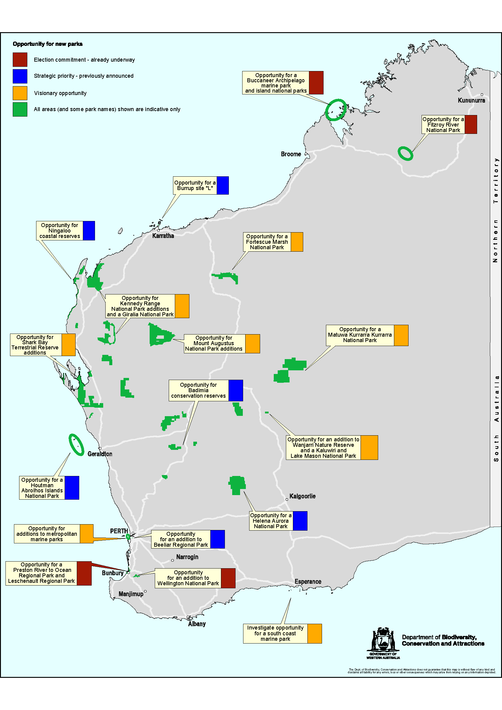
The Western Australian Government plans to increase the state’s conservation estate by 20 per cent over the next five years as a part of the government initiative, Plan for Our Parks.
The plan will see five million hectares of land dedicated to new national marine parks and reserves across Western Australia. The move comes as a response to a number of findings uncovered from formal enquiries into the current management and establishment of these spaces.
Plan for Our Parks prioritises the long-term management of these reserved areas through co-management agreements with Indigenous groups. The agreements with both Prescribed Body Corporates and Indigenous Ranger Groups are imperative for responding to the biodiversity, native title and mineral prospectivity of these reserved areas.
Where is Plan for Our Parks taking place?
A multiagency Directors General Steering Group oversees Plan for Our Parks, and the Ministers for Environment, Aboriginal Affairs and Mines and Petroleum are responsible for its approval.
The government’s pastoral leases under the plan are situated from the Kimberley region in the north, through to the South West region as well as a possible new marine park on the southern coastline
These areas have been selected due to their richness in conservation and cultural heritage values. The initiative seeks to prioritise relationships with traditional owner groups for the joint management of these new parks and reserves.
How are Traditional Owners being involved?
Marine and national parks generally require the consent of Native Title holders through an Indigenous Land Use Agreement (ILUA) in accordance with the Commonwealth Native Title Act 1993. This means that as a part of the Plan for Our Parks initiative, the Western Australian Government is seeking to successfully resolve any outstanding Native Title consent relevant to the initiative's estate.
In order to create new parks, the Western Australian Government works collaboratively with Traditional Owner groups through generating land use agreements with Prescribed Body Corporates (PBCs).
PBCs are established to protect and manage Native Title rights and interests once a native title determination is made. Learn more about PBCs here.
Joint management agreements that are already underway throughout the state include collaborations with the Yawuru, Miriuwung and Gajerrong, Bunuba, Dambimangari, Karajarri, Balangarra, Murujuga, Nyangumarta and Ngarla groups.
Through these co-management agreements, steward custodianship is taking place. That is, those who manage and supervise these reserved lands are now also responsible for its care. As Traditional Owner groups and PBCs are the identified groups to undertake this steward custodianship, these lands will be reintroduced to traditional land management and Indigenous stewardship practices.
Read more about where there are opportunities for new national parks here.
What skills are useful for groups involved in the Plan for our Parks initiative?
Plan for Our Parks is designed to complement the existing AUD $20 million Aboriginal Ranger Program that was established in 2017 through generating employment opportunities in the form of on-country jobs for Indigenous rangers. It also supports Aboriginal peoples’ commitment to reclaim the management and maintenance of their country.
While PBCs and Indigenous Ranger Groups work collectively to manage these reserved lands, they must be provided with the appropriate resources and infrastructure to manage lands in a modern context - particularly from a geospatial perspective.
Geospatial skills will be useful for those with steward custodianship so that they are equipped to map their lands and plan for impact, manage their data and information, and make informed decisions about their lands and communities.
Training is available via the Indigenous Mapping Workshop (IMW) Australia, which is dedicated to delivering culturally appropriate and inclusive geospatial training for Indigenous leadership, agencies, and communities to support Indigenous rights and interests.
IMW Australia specifically builds its training materials for Indigenous Ranger Groups and Native Title Organisations. More recently, the IMW Australia team has launched an online learning platform, IMW Australia - On Demand. This platform is free to access for all accepted participants across Australia and material is available all year round.
Winyama is one of the only Indigenous digital consultancies in Australia that specialises in mapping and GIS. As the host organisation of the IMW Australia, we have expertise in teaching culturally appropriate GIS training to Indigenous Ranger Groups and Native Title Organisations, and an unmatched understanding of Indigenous mapping.
Get in touch with our team today to learn more about how we can help you with your Native Title project, or how you can begin accessing free and specialised GIS training through IMW Australia.


