I’ve got drone data, now what?
Unmanned aerial vehicles (UAVs) or better known as drones, are becoming an increasingly popular way of visualising and monitoring landscapes.
With less entry barriers than traditional aerial or satellite imagery, drones can capture higher resolution images than satellite imagery and provide more flexibility in capture point perspective and angle.
Drone data is useful for archiving and monitoring changes detected on landscapes by reviewing captured images, but what else can we do with this data? Can it be incorporated into other land monitoring tools and workflows?
We’ve listed a few different ways that you can begin incorporating your drone imagery data into your Geographic Information Systems (GIS).
Orthomosaics
An orthomosaic is a drone map composed through stitching together many individual still images of a landscape. This process corrects photo angles, camera skew and lens edge distortion to create an accurate ‘birds-eye-view’ image of a large landscape, and the mosaic is positioned in real world coordinates.
Learn more about orthomosaics here.
The data in an orthomosaic is presented in a similar fashion to satellite imagery however, when properly processed it can be more accurate and can be zoomed in and out without distortion.
While traditional aircraft mounted aerial photography can achieve similar resolution, it is far more costly. Incorporating UAV flown imagery into your workflows can drastically improve the quality of imagery for a particular area, at an affordable price point. This can improve efficiency in the following areas:
Mapping weeds and feral animals
Monitoring water and river systems
Practicing fire management regimes
Mapping vegetation
In order to create an orthomosaic, you’ll need to create a flight plan for your drone. It is important to note that not all drones can be programmed to fly a route, and this is something to be aware of if you are purchasing for this purpose.
Drones that can be programmed require a software, such as DroneDeploy, Pix4D Mapper or AgiSoft Metashape. This software will allow a user to specify an area of interest and calculate the optimal flight path for you. When you fly on that path, the drone will be able to capture all the photos it needs to build the best orthomosaic.
Software such as Google Earth Pro allows you to use a pre-prepared orthomosaic as an image overlay. By using this method, you can update areas in your Google Earth project with more recent, higher-resolution custom imagery.
Watch this example of how orthomosaics are perfectly placed within the landscape:
Photogrammetry
Another opportunity to integrate drone data into GIS is through the creation of Digital Elevation Models (DEMs), which are three-dimensional (3D) models of the surface of an area of land. This is achieved using photogrammetry, a method of extracting 3D measurements from two-dimensional (2D) data.
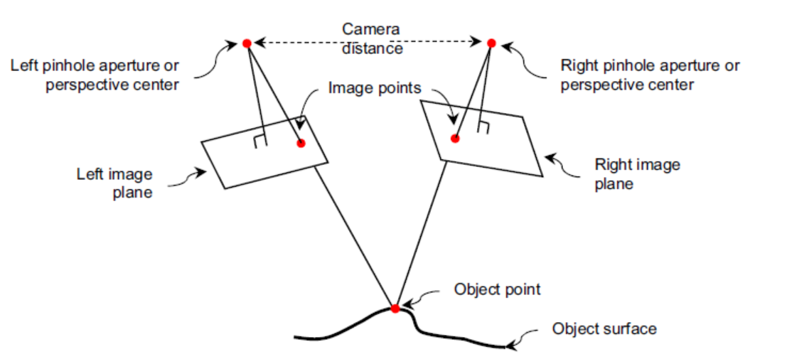
Photogrammetry is a technique that overlaps images in the drone dataset to perform distance calculations. This overlap is achieved by using a carefully selected flight plan, much like in the creation of an orthomosaic.
The triangulation method, which measures a network of triangles, calculates the distances between points and the camera’s lens to determine where the overlaps lie.
Look at this diagram of the photogrammetry technique.
The product of this technique is a 3D DEM of the terrain surface. A regular orthomosaic can then be draped over the terrain model to create a 3D look at the landscape. Using this technique you can create your own landscape model like we’re used to seeing in Google Earth.
Among the many benefits to mapping country in 3D, photogrammetry can also improve the the collaboration process with Elders in processes such as:
Land and coastal modelling analysis
Land management mapping
Industry consultation
To start using your drone data in photogrammetry, there are both commercial and open source softwares to help you.
Products from Skyline are a great commercial option for creating landscape models and applying photogrammetry. Skyline’s TerraBuilder builds globes and terrain models by draping imagery over DEMs and Skyline’s PhotoMesh builds 3D Mesh models out of geotagged images (photogrammetry). Skyline’s TerraExplorer can then be used to view these terrain models.
The same softwares mentioned above for creating flight paths can also be used to process the resulting data to perform photogrammetry. These include Pix4d, Agisoft Photoscan and Drone Deploy. A free and open source tool also exists called OpenDroneMap which is fully featured but has a slightly higher learning curve. See all of OpenDroneMap’s features here.
Pop-ups and multimedia
Some 3D mapping softwares, such as Google Earth and Skyline’s TerraExplorer, have the capability to embed multimedia pop-ups of drone imagery into your maps.
Pop-ups help you embed additional data in your map and can be used as a tool for presenting rich content about particular places on the map.
While it is common for pop-ups to host interview footage, translations or background information in heritage mapping, they are also an excellent opportunity to host drone footage to display finer and more specific details within the landscape
Watch this clip showing how pop-ups can host multimedia information within a map:
Winyama offer a range of different services. If you are looking for mapping services to improve land management monitoring go to ‘Our Services’ page .
If you have drone data and want to learn more about how you can use it, get in touch with our team.

