Partnerships to Cultivate Resilience: Indigenous Mapping Training in Western Australia
Western Australia’s Department of Primary Industries and Regional Development (DPIRD) fosters the sustainable growth and preservation of the state’s agriculture, aquaculture, food and fisheries sectors. DPIRD’s Aboriginal Economic Development (AED) team works directly with Indigenous organisations and, in line with their Strategic Intent 2022 - 2026, supports building capacity and business resilience to activate native title opportunities and unlock land/sea potential through business development. The AED team’s stakeholders are diverse, spanning from large prescribed bodies corporate (PBCs) and regional corporations with dedicated land management teams to small family-run agribusinesses. Despite the variety, they all share a common need for geospatial skills, which is ultimately what led DPIRD to support business resilience training at the National IMW 2024 - Boorloo.
A Shared Purpose
One of DPIRD's key objectives is to build resilience—whether business, social, or environmental—in regional Australia. Through funding from the Federal Government’s Future Drought Fund, DPIRD identified a strategic opportunity to work directly with Winyama on the delivery of training content specific to drought and business resilience at the National Indigenous Mapping Workshop 2024 - Boorloo. Kate O’Connor, a Project Manager within the AED team at DPIRD, has worked across Indigenous land management for 13 years. Kate recognised that building the geospatial capabilities and skill sets of those working in this sector is invaluable, as so many land-related decisions are at stake for organisations of all sizes. A newly established ranger group, for example, can gain fundamental skills in data capture and data labelling - ensuring they are set up for success from the beginning. More established groups may be ready to understand how to perform advanced analysis - running Python scripts in Google Earth Engine to find at-risk water sources. By sponsoring an already well-established Indigenous-led training initiative, DPIRD was able to tap directly into our shared audience and achieve greater impact through collaboration, bypassing the significant financial and time investments that would have come with undertaking similar efforts alone.
“We've got a particular kind of mandate to empower Aboriginal Australians in agriculture, fisheries, forestry, carbon farming, biodiversity management. And that can only be further enhanced by geospatial technology.”
Kate O’Connor, Project Manager at the Department of Primary Industries and Regional Development
One of the main appeals for supporting Winyama’s Indigenous Mapping Workshop, Kate said, was the ability to influence the training offerings at the event. In this instance, the funds were directed towards supporting the development of the Earth Observation sessions. DPIRD has its own objectives around building a more drought-resilient state, and by collaborating with Winyama, they’re able to meet those outcomes.
Celebrating Outcomes
“I’m glad it was held in WA, flights and accommodation made it cost-prohibitive to go to Melbourne.”
Katrina Nissen, National IMW 2024 Learner
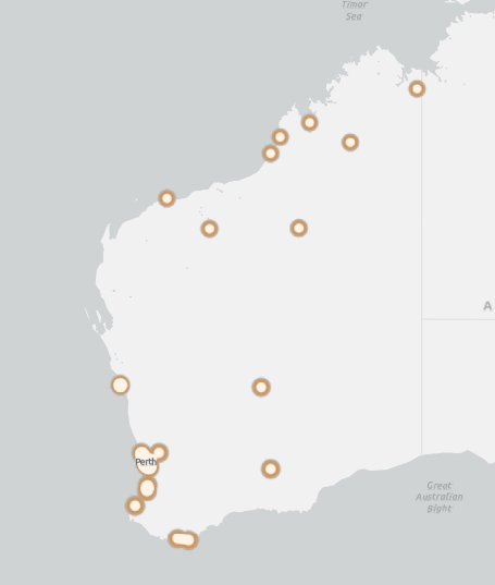
West Australian National IMW 2024 attendees and where they are based.
It had been five years since the National Indigenous Mapping Workshop was held in Boorloo, which meant that Western Australian attendance was strong. Of the 103 learners who attended the workshop, almost 70% were from regions in Western Australia. Compared to National IMW 2023 attendance where only 13.4% from Western Australia travelled to Melbourne.
"It's so valuable for people to get together and say, 'Hey, wait a minute, you're doing something similar to us' or, 'you're doing what we were doing three years ago - this is how we approached it'. That's where this program thrives. You create space for people to get together and learn from each other as well."
Kate O’Connor, Project Manager at the Department of Primary Industries and Regional Development
Kate explained that DPIRD report back to the Federal Government, and the datasets and reporting Winyama provided, particularly highlighting the training around drought resilience, will be submitted to them to feed into the design of Indigenous-specific programs under the Future Drought Fund. She noted that the captured data, report style, and graphics were easy to digest, making it simple to understand the breadth of impact and outcomes from the IMW beyond number of people being trained.
Sponsor our Indigenous Mapping Workshop Australia Program
Do you work for a Government department with a Reconciliation Action Plan or strategic initiatives for your Indigenous community partners? Get in touch with us to find out how our program can make a difference for you and our Mob.

